
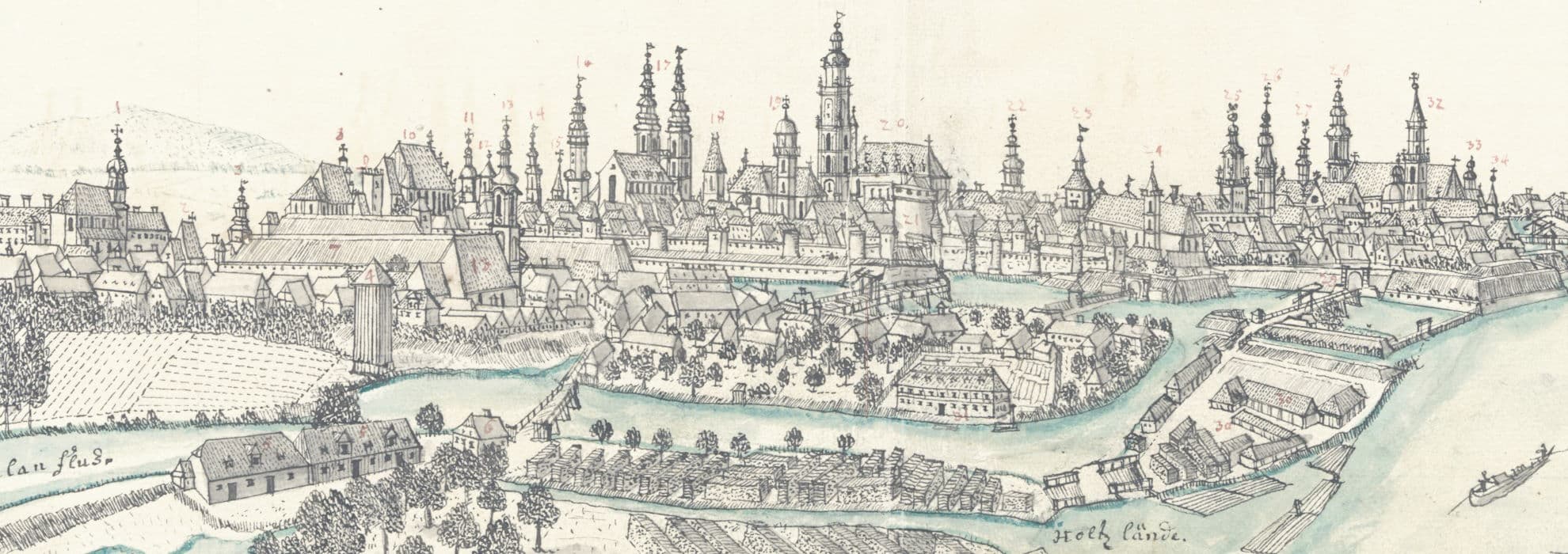
- Belegering der Sterke Stad, Buda of Offen, door de Keyserlyke en Geallieerde Machten.
Szczegóły obiektu: Belegering der Sterke Stad, Buda of Offen, door de Keyserlyke en Geallieerde Machten.
IIP
Struktura
Atlantis Cosmographici Variorum Autorum a Machnizkiis collecti.
Opis
- PLMET: http://confluence.man.poznan.pl/community/display/FBCMETGUIDE

- Tytuł:

- Twórca:
- Temat i słowa kluczowe: ; ; ; ; ;
- Opis:
- Miejsce wydania:
- Wydawca:
- Data:
- Szczegółowy typ zasobu:
- Format:
- Identyfikator:
oai:bibliotekacyfrowa.pl:43252 - Źródło:
- Język:
- Prawa dostępu: ;

- Licencja: ; https://creativecommons.org/publicdomain/mark/1.0/deed.en ;; https://creativecommons.org/publicdomain/mark/1.0/deed.pl
- Lokalizacja oryginału:
- Autor opisu:
Obiekt znajduje się w kolekcjach:
Zobacz także
Buda. Ofen in Ungarn
Twórca:Wernher, Friedrich Bernhard
Data:[ca 1730]
Źródło:2656-IV.B.
[Ubiory w Polsce 1200-1795. Przez J.Matejkę. Album sztuczny. Okładka]
Twórca:Matejko, Jan (1838-1893)
Data:[1875 ?]
Typ:obraz
Źródło:752334 III
Landschaftliche Motive, Architektur Aufnahmen, Natur Aufnahmen.
Data:1929-05-01–1931-07-30
Źródło:Inw. fot. 6815/1-77
[Staszowice. Aleja brzozowa]
Data:1929-05-01–1931-07-30
Źródło:Inw. fot. 6815/1-77
[Richter]
Twórca:Bock, Eduard (1804?-1834)
Data:1833
Źródło:Inw. graf. 7812
Atlas nouveau a l'usage de Monseigneur le duc de Bourgogne, contenant les cartes geographiques de toutes les parties du monde [...] reveués, corrigées et enrichies des decouvertes des nouveaux Geographes de l'Academie Royale des Sciences [...] par [...] Sanson D'Abbevile. T. 2.
Twórca:Sanson, Nicolas d'Abbeville (1600–1667)
Data:[1696-1708]
Źródło:968-IV.B.
[Wrocław. Festyn św. Jana]
Data:1929-06-27
Źródło:Inw. fot. 6815/1
[Wrocław. Gmach główny Uniwersytetu]
Data:1929-07-16
Źródło:Inw. fot. 6815/4


